EVANGELINE LAKE GOLD PROPERTY
EVANGELINE LAKE GOLD PROPERTY OUTLINED
Technical Information:
“The Evangeline Lake Property consists of 27 map designated mining claims covering 675 hectares (1,668 acres). It is situated in McKinnon Township in the Sudbury Mining District - a major gold mining center in Central Ontario - and located approximately 20 km southwest of Espanola on the north shore of Evangeline Lake and approximately 70 km southwest of the town of Sudbury. It can be reached by a 30 km gravel road which branches south from Highway 17 West at Webwood.
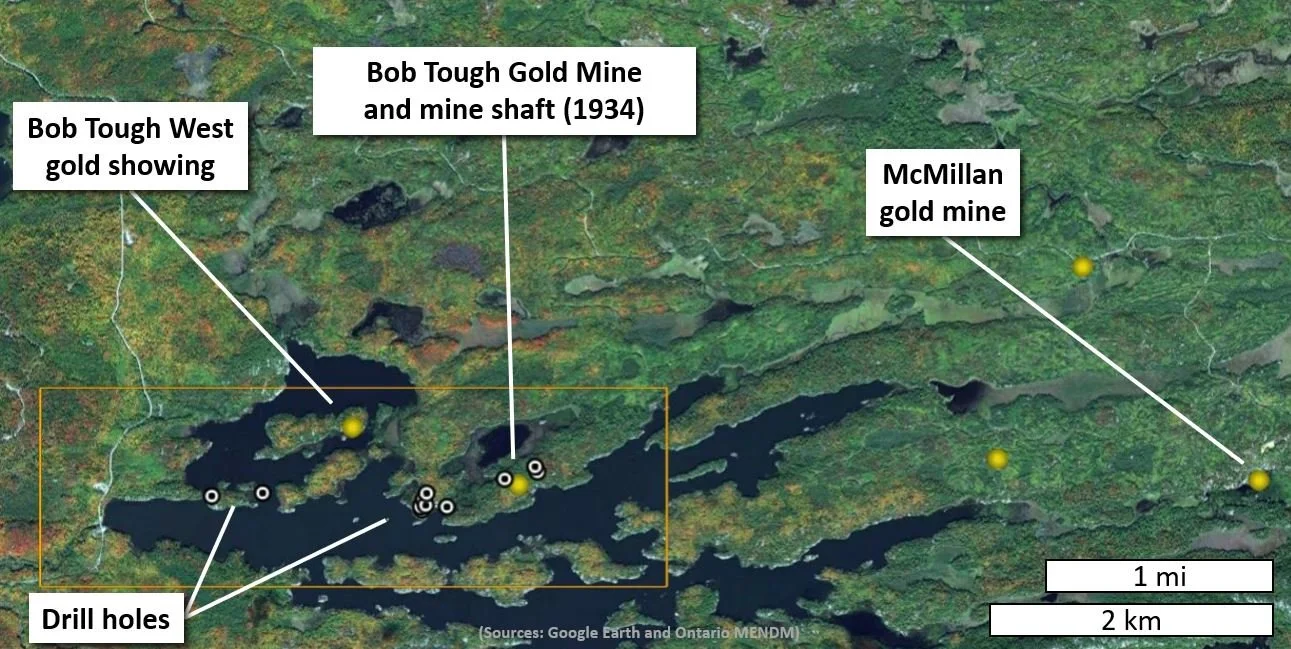
The Property lies within a belt of Huronian metasediments which strikes east-west for a distance of 53 kilometers. Numerous gold occurrences are found within this belt adjacent to the Charlton Lake Fault in association with diabase dykes. Several old gold and silver producing mines exist within this metasedimentary belt. These mines were active during the late 1930's and early 1940's. These include the McMillan Gold Mine, Majestic Mine, Bousquet Mine, Hawry Creek Mine, Upsala Mine and Bob Tough Mines which one is the closest to the Property.
Tough Gold Mines Limited carried out surface exploration and diamond drilling on the Property. Based on these results, a three-compartment shaft was sunk to the 150-foot level, where 118 feet of cross cutting was completed. Gold values up to 6.6 g/t Au over 1.36m were recorded for holes drilled by the company during the late 1930's.
The Evangeline Lake Property is similar to the before-mentioned gold properties in the mineralogical and structural nature of the gold mineralization. The gold bearing quartz-carbonate veins in the area are apparently associated within and at the contacts of folded quartzite and pelite units in close proximity to diabase sills and dikes. Gold occurs in its native state and intimately associated with arsenopyrite, pyrite, pyrrhotite and chalcopyrite. The gold bearing vein systems are associated with fault/shear zone environments and at pelite/quartzite contacts.
Grab samples taken from the rock dump and old pits on the Bob Tough Mine have yielded gold value from trace to 25.9 grams per ton (Report 41I04NW0046).
In June of 1984, J. K. Filo (1984) mapped the area. In his report Filo reports assay values from dump material samples near an old shaft. Gold values range between 0.0125 and 112.8 g/t of gold in this samples (Report 41I04NW0045).
In 1988 a geophysical survey was done on the Property. The contoured Magnetometer/VLF-KM surveys outlined numerous EW trending conductors and magnetic anomalies.
The Property is located within a favorable geological and structural environment already hosting several gold-bearing zones. An exploration program including geological and geophysical surveys is necessary to generate targets for more detailed exploration works.